
It started with a discussion about Roman and neolithic sites, when Matthias, tutor on the farm brought out host of hand drawn maps of the Nailsworth-Stroud area which showed the layers of History in the area. one was of the original hunter-gatherer land showing all the natural formations, overlaying that was some neolithic and roman sites, overlaying that was the saxon and Norman buildings and over that was the Industrial sites showing all the mills in the area..about fifty!.
What interested me the most, however, was the roman and neolithic sites. besides the Roman roads, one being the Fosse way that I travelled along and will tell you about in my next blog, where I visited a Roman villa.
What struck me was the host of neolithic and Roman artifacts just near where I live in Minchinhampton. It also noted that there were standing stones at a place evocatively called ‘the Devils churchyard”. 
I read up on some Minchinhampton history, and found that several attempts to build a church there, on the site of a stone circle, enabling Christianity to gain a stronger hold among the heathens of the neighbourhood, foundered when the project was continually vandalised. Some said it was the devil’s work as the site chosen for this new structure was an ancient site of Pagan worship, and, legend has it, all work that was accomplished during the day was at night torn down, supposedly by the devil. Eventually the work was abandoned, and the new church was constructed on its present site in Minchinhampton itself. Later, a clergyman ordered destruction of the stone circle, and the locality gained a reputation for evil. A ghostly rider sometimes put the wind up passers-by, and a grim spectre was seen following people in the lanes. On one occasion an old man made his way along the track that led across the area, a faint sound of tinkling bells reached him across the fields to the south. He stood and listened. The noise grew louder. Then quite suddenly from over the hedgerow leapt a horse and rider. The bells jangled loudly as the horse landed after its unnaturally high jump. The man’s blood froze as he saw the rider; a black-robed, ghostly figure, an ethereal corner of the rider’s garment flicking at the man’s face as the pair galloped off up the valley and disappeared into the darkness. 
It was the Sunday after halloween when I went searching by foot, on the other side of a little place called Crackstone.  The track was full of slippery mud, and both sides were covered in stinging nettle, blackthorn and hemlock. There was sense that people were not welcome, and the only way you could get there was by horseback.
  Anyway, I had walked a long way, and was not going to turn back.
  Eventually I found the abandoned churchyard, covered in trees, nettle and fox holes. the fox holes uncovered partially covered walls,
 and it had an eery feeling with a strange high humming through the trees. I spend some time just feeling the place and looking for evidence of the church.
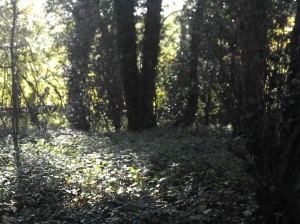 All that was left of a church was some low bumps in a squarish shape, and of course surrounded by old dry walls covered in moss.
  The stone circle had been removed, and it is believed that they have been used in various places and lost their identity.
However, two standing stones remain in the area , and they even have a more bizarre reputation. They were a length away from this site. More walking. Here are to be found some of the best-known standing stones in Glouchestershire – the Long Stone and the Tingle Stone. The tingle stone was on the Princess Royals land at Gatcombe Park. So the local police keep a watch out for strangers. I just walked in, but couldnt find it, and was a little scared as I heard barking dogs.. It has long been thought to be charged with electricity. It is thought to be the remains of a portal dolmen Or marking stone, connected with a long barrow.
A long barrow was the last phase in a complex sequence connected with the ritual burial of the dead that took place in British society between around 4000 and 2400 BC. Many long barrow sites started off as small rectangular enclosures of earth banks topped by timber walls, enclosing a kind of mortuary. Within this was built a wooden room-sized mortuary chamber with large supporting posts. Sometimes a grand timber entrance was also built along with an an entrance of wooden posts. Human remains were placed in this chamber, sometimes all at once and sometimes over a period of time. Often the bones found in them are in bits and pieces, implying that the bodies were subjected to exposure prior to burial or that they were buried elsewhere and exhumed for the purposes of placing in the barrow. Rarely are whole skeletons found and it seems that only long bones and skulls survived until the final internment.
Up to fifty separate individuals were placed in each enclosure, males, females and children. Chambers were then surrounded and covered by large stones or were set alight. Only after these procedures was the earth barrow constructed over the top of the dead, making a mound.
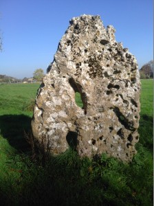 The long stone stands on its own without a barrow mound and is a little bit away and more easily accessible. Local legend has it that, when church bells strike at midnight, the Tingle Stone and the Long Stone run around their fields. They are also said to go to Minchinhampton to drink from a spring there.
The Long Stone, a rough lozenge shape is 7 ½ ft high above the ground, and is said to be as much below the surface. Is famous for the two large holes in it, which, although created by natural weathering, have given rise to various folk tales. The stone was thought to have healing properties. People would pass their limbs through the holes for cures, and mothers would put their children through to keep them healthy. Within living memory, children with whooping-cough and rickets used to be put through one of the holes in the stone. (the holes were not that big, so only a very small baby would get through there! )
It may also have been associated with fertility rites, as couples would hold hands through the stone and pledge themselves to one another. Traditions of bloodshed also cling round the Longstone; some say that it marks the burial place of a Danish chief killed in a battle at “Woeful Danes’ Bottom”, about half a mile distant, where “the blood ran as high as the wheels of a cart”, and the victory was won by women who gave the Danes poisoned pancakes to eat, and all the bumps or “tumps” in the neighbourhood are held to be “the soldiers’ graves”.
It’s also been said that a phantom black dog has been seen in the stone’s vicinity, carters had to blindfold their horses when they passed along the road in which the main gates to the Gatcombe estate lie. Reputed by witnesses who have seen it on a number of occasions, to be headless and nearly the size of a Labrador, it is said to move fast and silently, then brush up against you, with a pungent aroma of damp fur. Perhaps that was what was barking, keeping me away.
I found the long stone, and I must say it was reminiscent of good old cape town sandstone, with its characteristic weathering. Do you think it came that far? Who knows? I put my injured hand through the holes to get it healed.
After this, I walked back along Minchinhampton common,  and became more conscious of the bumps and tumps and realised there were many remains of past civilisations over which grew grass and made the best free golf course.
 I am not sure how many people realised what they were stepping over. Here are a few furrows and hollows and barrows? They are certainly not Natural formations.
I have asked why Minchinhampton common has never been excavated. One answer, was that the earth protects the artifacts. I must say that I cant relate to this. however, I read a statistic that farming in the last 60 years has destroyed more artifacts than the last 6 thousand years. I can believe that, as the fields are farmed extensively using bulldozers, tractors and ploughs. Thus, the fact that the common is only used for grazing EVERYBODY’S cows and a golf course, place to walk the dogs and ride horses is protecting it. Maybe one day it will be excavated. Below are some Sunday golfers

These are not standing stones, but wooden posts that protect the green!
Below is a long furrow possibly used for water in roman times?
 Every house has a cattle grid as the cows are allowed free reign. They are good at damaging property, and damaged my side mirror when they came herding down the hill past my house!

So interesting, thanks for that. Must be wonderful walking around all that ancient history, even better if some of it is a bit spooky.
LikeLike
Especially if some of it is a bit spooky!
LikeLike
You can see where Macbeth came from. I saw a BBC programme where they use lasers to see what is under the grass so they know what’s down there before they start excavating.
LikeLike
I am fascinated by the idea of the stone circle but not sure if it is a fallacy … I have also walked down the same path toward what is called the Devil’s Churchyard (it is an area of woodland on a slope to the left) but says private property…. I could not see any ruins (as you outlined)…. If there was a stone circle it could not have been in this spot as it is not flat. Very curious. Perhaps if it existed it was further on just past what is called the Devil’s Churchyard – indeed from aerial photographs there does appear to be some sort of a circular marking in the ground but of course this might be something else rather than an indication of any form of stone circle remnants. It is a mystery and one that is intriguing. Any help / advise / comments are gratefully received. Gary Chapman (gazchappers@btinternet.com)
LikeLike
I used an old map that I found at Ruskin Mill (at the farm kept in the attic) to orientate myself. The area i found was under some nature conservation “protection”. There was a fence around a part of it. If you go further it is private. The road was very wet and muddy and I got to a point where i couldnt go further. That whole area was on the edge of farmland and had also been graded and damaged. I am not sure it was protected. I am not sure who owns the land there. They may know more. There is a Minchinhampton historical society…they may know more. The whole area is very interesting.
LikeLike